


Thompson, Bullock County, Alabama
About
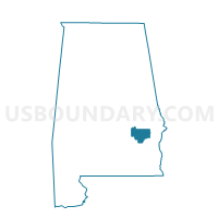
Outline

Summary
| Unique Area Identifier | 521268 |
| Name | Thompson |
| County | Bullock County |
| State | Alabama |
| Area (square miles) | 37.27 |
| Land Area (square miles) | 37.15 |
| Water Area (square miles) | 0.12 |
| % of Land Area | 99.68 |
| % of Water Area | 0.32 |
| Latitude of the Internal Point | 32.20638440 |
| Longtitude of the Internal Point | -85.82803860 |
Maps


Graphs
Select a template below for downloading or customizing gragh for Thompson, Bullock County, Alabama


Neighbors
Neighoring Voting District (by Name) Neighboring Voting District on the Map
- Cornerstone, Bullock County, AL
- Fitzpatrick, Bullock County, AL
- Ft Davis Old District 2 Shop, Macon County, AL
- Hardaway Volunteer Fire Station, Macon County, AL
- Union Springs Armory, Bullock County, AL
Top 10 Neighboring County Subdivision (by Population) Neighboring County Subdivision on the Map
- Union Springs CCD, Bullock County, AL (7,102)
- Shorter-Hardaway CCD, Macon County, AL (2,309)
- Fitzpatrick CCD, Bullock County, AL (750)
- Fort Davis CCD, Macon County, AL (726)
Top 10 Neighboring Place (by Population) Neighboring Place on the Map
Top 10 Neighboring Unified School District (by Population) Neighboring Unified School District on the Map
Top 10 Neighboring State Legislative District Lower Chamber (by Population) Neighboring State Legislative District Lower Chamber on the Map
Top 10 Neighboring State Legislative District Upper Chamber (by Population) Neighboring State Legislative District Upper Chamber on the Map
Top 10 Neighboring 111th Congressional District (by Population) Neighboring 111th Congressional District on the Map
Top 10 Neighboring Census Tract (by Population) Neighboring Census Tract on the Map
- Census Tract 9522, Bullock County, AL (7,102)
- Census Tract 9525, Bullock County, AL (2,378)
- Census Tract 2322, Macon County, AL (2,309)
- Census Tract 2323, Macon County, AL (1,750)